In »How to debunk evidence of a flat earth« I presented two methods to debunk a picture that according to Flat Earthers prove that the earth is flat and not a sphere.
In the video Just Open Your Eyes … The Earth is FLAT (Old Taboo) from @tabooconspiracy is a second false »prove« which resembles the »prove« with the mountains of Mallorca. The difficulty is that there is no clear horizon in this image from which to measure the height of the mountains. But more on that later. Let’s first check whether the mountains have been correctly identified at all.
First assumption: Here clouds identified as mountains. This assumption fits the discrepancy between the real height and the visible height of the mountains in the image. Very high mountains are lower than very small ones.
First we need more data. For this we search out the positions and heights of the mountains and other places in Google, OpenStreetMap and other databases.
Google Maps returns a slightly more accurate position (15 decimal places) than OpenStreetMap (5 decimal places) when it includes the mountain. The accuracy of OpenStreetMap is completely sufficient at around one meter.
After that we calculate the distances, the horizon around and the bearing from Pic de Noufonts to the places and mountains. The result is the following table.
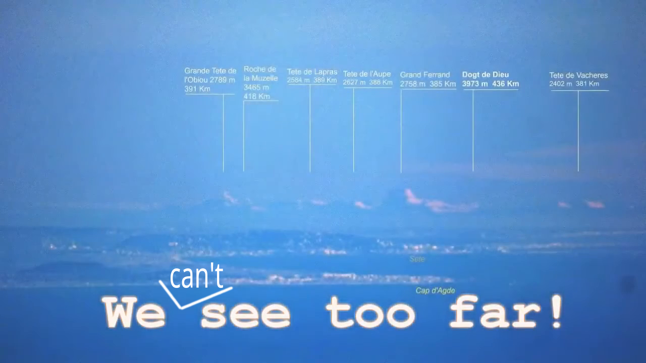
| Mountain | Lat | Lon | Height | Horizon | Distance | HeightPx | Heading |
| Pic de Noufonts | 42,42472 | 2,16750 | 2.861 | 190.953 | 0 | 0,000 | |
| Le Mourre Blanc | 43,40447 | 3,57840 | 0 | 0 | 158.331 | 46,045 | |
| Farinette Plage | 43,29035 | 3,41492 | 0 | 0 | 140.008 | 46,147 | |
| Balaruc-les-Bains | 43,43573 | 3,67235 | 0 | 0 | 166.274 | 46,951 | |
| Feu de la jetée Est du Grau-d’Agde | 43,28005 | 3,44381 | 0 | 0 | 140.959 | 47,136 | |
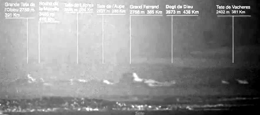
| Grande Tete I’Obíou | 44,77500 | 5,83972 | 2.789 | 188.534 | 394.562 | 142 | 47,275 |
| Roche de la Muzelle | 44,93082 | 6,10637 | 3.465 | 210.150 | 421.800 | 132 | 47,314 |
| Tete de Lapras | 44,75720 | 5,84110 | 2.584 | 181.472 | 393.371 | 126 | 47,506 |
| Tete de l’Aupet | 44,74417 | 5,82962 | 2.627 | 182.976 | 391.745 | 123 | 47,583 |
| Le Grand Ferrand | 44,72140 | 5,81550 | 2.758 | 187.483 | 389.268 | 146 | 47,764 |
| Doigt de Dieu | 45,00470 | 6,31360 | 3.973 | 225.033 | 439.597 | 117 | 47,855 |
| Tete de Vacheres | 44,67489 | 5,79866 | 2.402 | 174.963 | 384.951 | 124 | 48,230 |
| Sete | 43,40755 | 3,70075 | 0 | 0 | 165.925 | 48,285 | |
| Port du Cap d’Agde | 43,27856 | 3,50687 | 0 | 0 | 144.686 | 48,537 | |
| Tête de l’Estrop | 44,28722 | 6,50472 | 2.961 | 194.262 | 407.172 | 57,958 |
First argument
The table shows that the Tete de Vacheres is on the left of Sete and Cap d’Agde and not on the right. The mountains lie between 47.275° in the north and 48.230° in the south.
Let’s look at this on Google Maps by drawing a triangle between Pic de Noufonts, Tete de Vacheres, Grande Tete I’Obíou and back to the Pic de Noufonts.
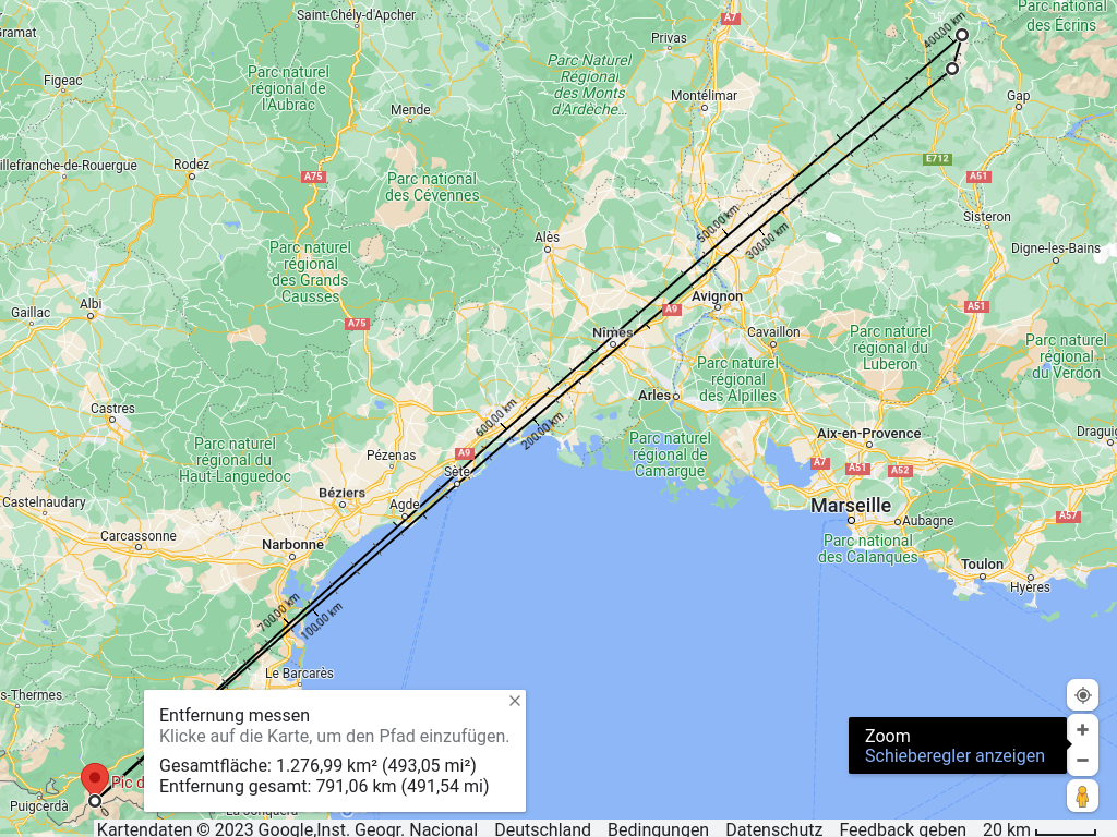
Now we zoom into the map in the area around Sete and Cap d’Agde.
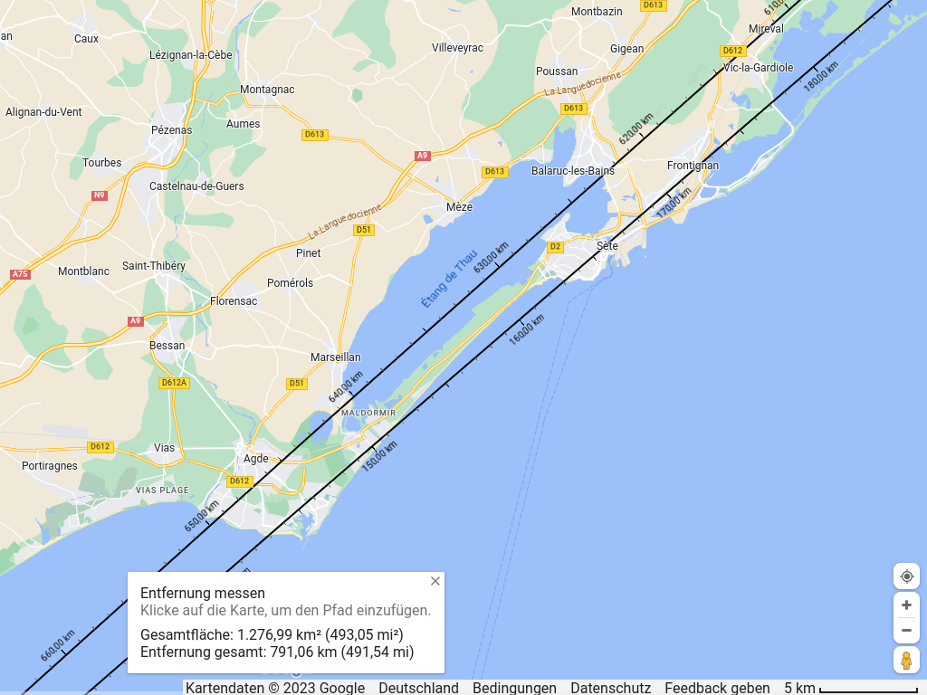
This map section shows that the mountains are all to the left of Sete and significantly more in the right third of the Étang de Thau, right of Balaruc-les-Bains.
There is only a small band of 132 pixel in which the seven mountains would be visible. And in this small band ist only one … cloud.
At least five of the seven mountains are misidentified as clouds. Therefore, this image is not proof that the earth is flat.
Second argument
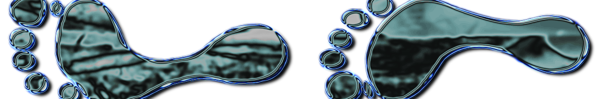
We don’t have a clear horizon, but we can measure the height of the supposed mountains from any line. In this case we make a constant error of x pixels. In order to be able to recognize and measure the heights better, I enlarged a section, converted it to black and white, increased the contrast and reduced the brightness. The measurement is taken from the bottom edge of the image.
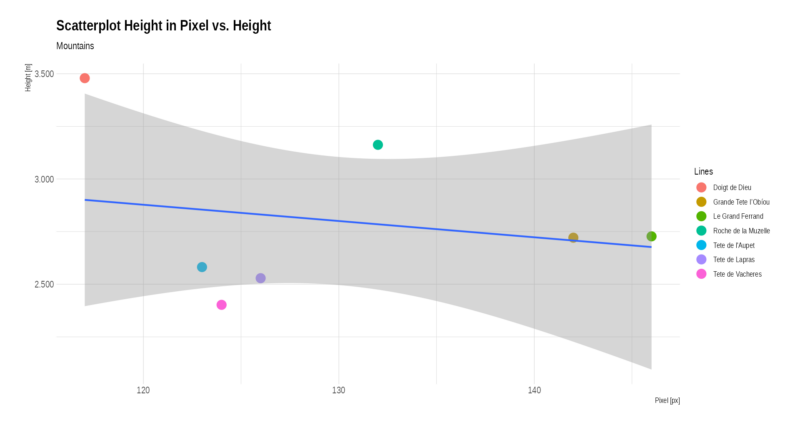
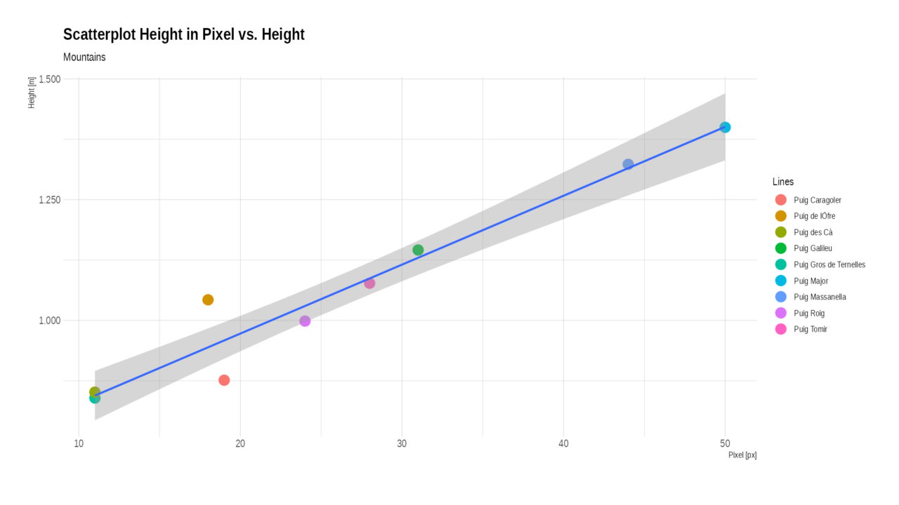
We enter this height in the pixel and the real height in a scatterplot. The result should be approximately an ascending, straight line. The distance difference between the mountains is only +/- 5%. We can correct this by converting the height of the mountains to the distance of the mountain that is closest.
I remeasured the image of Mallorca and we get the following scatterplot. It shows that the lower 700-800m of the mountains are obscured by the horizon. We expect a similar picture for the view from the Pic de Noufonts.
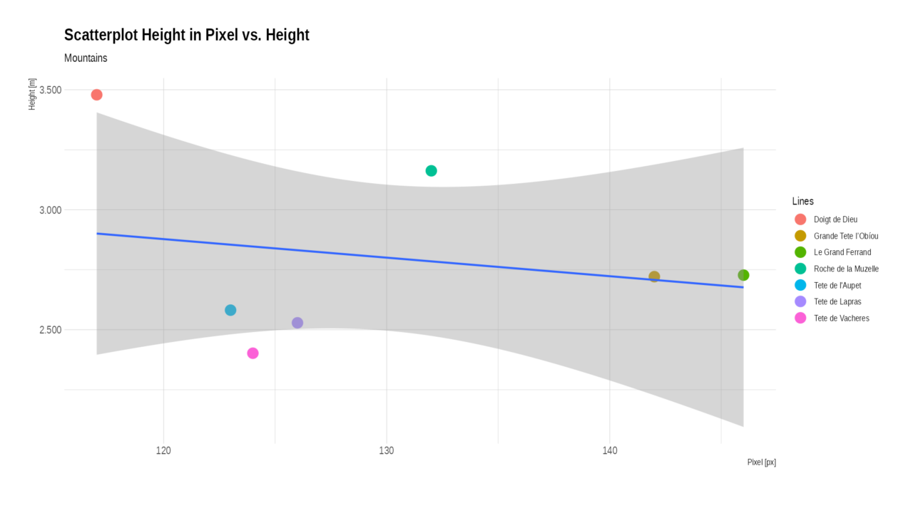
The scatter plot below clearly shows no linearly increasing relationship between the actual height of the alleged mountains and the height in the image.
This is the second reason why this picture is not proof of a flat earth.
Conclusion
Clouds were mistaken for mountains.
Please keep in mind, that the pictures of Mallorca from Observatori Fabra, Barcelona, Spanien are perfect proves that the earth can not be flat.
Neueste Kommentare